Surveying Equipment
GNSS Equipment
Oscar Trek GNSS Receiver

Features:
The Oscar Trek includes a camera for Visual Positioning to extract points from photos in the field.
-
Supports multiple constellations and frequencies
-
Supports 576 channels
-
Innovative visual positioning technology for precise measurements
-
410-470MHz UHF radio, 4G network, Wi-Fi, Bluetooth, NFC
-
Tilt compensation without calibration, immune to magnetic disturbances


TAP Real-Time Corrections

Features:
-
Centimeter-level accuracy, 1.5cm horizontally and 3cm vertically.
-
Rapid Convergence, less than 3 minutes from turning on the GNSS Receiver.
-
Global Coverage, Offer the freedom to work anywhere with at least 2 satellites covered.
-
99.99% Availability, The redundant system architectures of global reference stations, network control centers, and satellite uplink and downlink contribute to superior service available anytime.
GeoBee


Features:
The Tersus GeoBee is an affordable permanent reference station, for transmitting or receiving NTRIP corrections. When combined with Tersus NTRIP Caster Service, NTRIP Modem, and David30 GNSS Receiver, the GeoBee enables users to easily send Real Time Kinematic (RTK) corrections via Ethernet, 2G/3G/4G connections using just a SIM card, or Ethernet cable, without requiring a static IP. The NTRIP caster service supports multiple bases simultaneously.
David30 GNSS Receiver

Features:
The David is a modular GNSS receiver that is built for flexibility and high performance across various industries.
-
Supports multi-constellation including BeiDou, GPS, GLONASS, Galileo, QZSS and SBAS
-
Supports 576 channels
-
Supports RTCM2.x/3.x, CMR/CMR+ corrections
-
Flexible for integration in different applications
-
Input power range is 5~28V DC —Note: Input of 28~36V DC can be customized.
-
Supports Nuwa surveying software
Total Stations
TAS-Z1 Total Station

Features:
The TAS-Z1 mechanical total station is a high-precision measurement device designed for accuracy, speed, and versatility.
-
150MHz modulation for shorter ruler and higher accuracy
-
Optical path design isolates signals for precision
-
Supports EXCEL and DAT data import/export
-
Imports known point files usable across projects
-
Handles complex road curve calculations
-
Displays 19-bit code with clear stakeout info
-
Noise phase analysis reduces interference
-
Applicable to surveying, construction, traffic, water, cadastral, real estate, and deformation monitoring
Data Collecting Equipment
TC80

TC40
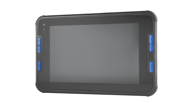
Features:
Opt for the robust TC80 5.5-inch data controller or the 8-inch TC40 rugged tablet controller as the core of your field data collection system. The TC80 is an ultra-lightweight, ergonomic handheld device designed for one-handed use. Meanwhile, the TC40, with its rugged Android tablet design, features a larger, high-resolution screen and offers cell phone capabilities.
NUWA Software

Features:
Nuwa is a field survey app designed for Tersus controllers or other Android devices (compatible with versions 6, 7 and later) that works seamlessly with Tersus Smart GNSS receivers. It features a graphical interface with a background map for CAD stakeout, road stakeout, Earthwork, tilt survey, and COGO tools for area perimeter, azimuth distance, and grid to ground calculations.
LiDAR Equipment
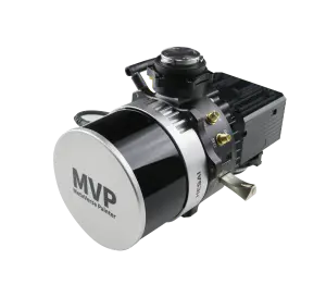
MVP S2


Features:
The Tersus MVP S2 is a professional-grade mobile 3D SLAM scanner that delivers sub-3 cm absolute accuracy using advanced RTK-SLAM technology. Whether handheld or worn as a backpack, it captures repeatable, high-resolution point clouds in real time, even in GNSS-denied environments.
The system includes a high-precision LiDAR, panoramic camera with a 1-inch Sony sensor and Leica lens, dual hot-swappable batteries (up to 3 hours of uninterrupted data collection per set), and full processing software.
Bathymetry Equipment
TheDuck

Features:
TheDuck is a high performance autonomous sonar boat.
-
Android/Windows operating system
-
Manual or Auto-Pilot navigation
-
Portable echo sounder: Automatically record data without PC & Retain original analog signal
-
Integrated communication system
-
RTK/PPP centimeter-level positioning
-
Remote control: Real-time display & Control distance up to 2KM