Share this article
Tersus MVP S1 Handheld 3D Laser Scanner for Surveying, Mapping & Construction
If you are searching for a Tersus MVP S1 handheld 3D laser scanner, there is a good chance you are comparing mobile LiDAR systems for surveying, construction, mapping, reality capture, or 3D point cloud collection.
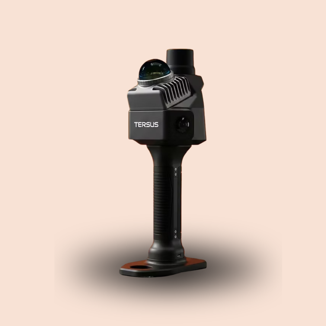
The Tersus MVP S1 is designed as a compact handheld SLAM scanner that combines 360° LiDAR, RTK/GNSS positioning, dual 48 MP cameras, real-time mobile preview, and high-density point cloud capture in one portable system.
For surveyors and field crews looking for a lightweight alternative to larger terrestrial scanning systems, the MVP S1 is positioned as a mobile solution for collecting 3D data quickly across indoor and outdoor environments.
What Is the Tersus MVP S1?
The Tersus MVP S1 is a handheld 3D laser scanner built for professional surveying, mapping, and reality-capture applications.
It combines:
- 360° LiDAR
- High-precision RTK/GNSS
- Dual 48 MP panoramic cameras
- SLAM-based mapping
- Real-time point cloud preview
- Onboard computing
- Mobile app connectivity
Tersus designed the MVP S1 for professionals who need portability without giving up high-density point cloud capture or positioning capability.
Tersus MVP S1 Specifications
One of the biggest reasons buyers search specifically for the MVP S1 is its balance between size, scanning speed, and field capability.
Key specifications include:
- Weight: 982 g including battery
- Point cloud rate: 200,000 points per second
- Scanning range: up to 70 m at 80% reflectivity
- Relative accuracy: less than 1 cm
- Absolute accuracy: less than 5 cm
- Field of view: 360° horizontal
- Cameras: dual 48 MP
- Operating time: up to 150 minutes
- Storage: 256 GB expandable
For buyers comparing a handheld LiDAR scanner for surveying, these are some of the most important specifications to consider.
Handheld SLAM Scanner for Surveying
The MVP S1 uses RTK-SLAM technology to support mobile scanning while the operator walks through a site.
Tersus states that its AI-driven SLAM algorithm works with RTK constraints to help maintain absolute positioning accuracy while reducing accumulated drift over larger projects. In GNSS-denied environments, the SLAM algorithm continues to operate to maintain the scan trajectory.
This makes the MVP S1 relevant for surveyors working in environments such as:
- Construction sites
- Buildings
- Parking structures
- Tunnels
- Industrial facilities
- Underground spaces
- Dense urban areas
- Forestry environments
For anyone searching for a SLAM scanner for surveying, the MVP S1 is designed specifically around mobile field collection rather than stationary scanning alone.
Tersus MVP S1 for Construction and Reality Capture
The MVP S1 can also be used for construction documentation and reality capture.
Its dual 48 MP cameras support panoramic imaging and 3DGS workflows, allowing users to collect visual information alongside LiDAR geometry.
That can make it useful for:
- Existing-condition surveys
- Construction progress documentation
- Digital twins
- As-built capture
- Site mapping
- Volume calculations
- Engineering surveys
- Infrastructure documentation
Tersus specifically lists applications including topographical mapping, engineering survey, volume calculation, underground space, forestry, geological exploration, emergency mapping, and smart-city projects.
Real-Time Point Cloud Preview
A major advantage of a handheld 3D scanner is being able to confirm data coverage before leaving the site.
The MVP S1 mobile app allows operators to view true-color point clouds and movement trajectories in real time. This helps crews identify missed areas and verify scan quality while still in the field.
For survey companies, this can help reduce the risk of having to return to a site because an area was missed during the original scan.
RTK/GNSS Accuracy
The MVP S1 includes integrated RTK/GNSS positioning.
The technical specifications list RTK accuracy of:
- Horizontal: 0.8 cm + 1 ppm
- Vertical: 1.5 cm + 1 ppm
It supports multiple satellite constellations including GPS, BDS, GLONASS, Galileo, QZSS, and NavIC.
For professionals searching for an RTK LiDAR scanner or a 3D laser scanner with GNSS, this integrated positioning is one of the MVP S1’s key advantages.
200,000 Points Per Second LiDAR
The MVP S1 captures up to 200,000 points per second, with a point cloud thickness of less than 1 cm.
The scanner provides:
- Up to 40 m range at 10% reflectivity
- Up to 70 m range at 80% reflectivity
- 360° horizontal field of view
For users comparing portable 3D scanners, these specifications can be especially important for outdoor surveying, engineering, and construction applications.
Tersus MVP S1 Point Cloud Export Formats
The MVP S1 supports common point cloud formats, including:
- LAS
- PCD
- PLY
- RCP
It also supports JPG image export.
This makes the captured data easier to move into established CAD, BIM, GIS, and point cloud processing workflows.
Tersus also provides desktop software for post-processing, colored point cloud export, image-point cloud integration, and display of RGB, elevation, and intensity data.
Smart Resume for Large Scanning Projects
For long jobs, the MVP S1 includes a Smart Resume function.
The system supports mission pauses and battery swaps, then automatically recognizes its position and stitches the new scan data to the previous session.
This can be useful for:
- Large sites
- Long corridors
- Road projects
- Industrial facilities
- Multi-building sites
- Large topographic scans
The listed battery operating time is up to 150 minutes.
How Much Does the Tersus MVP S1 Cost?
Pricing for professional 3D laser scanning equipment can vary depending on the package, accessories, software, and support included.
If you are searching for:
- Tersus MVP S1 price
- Tersus MVP S1 for sale
- Tersus laser scanner price
- where to buy Tersus MVP S1
- handheld LiDAR scanner for surveying
contact United Surveying Supplies for current pricing and availability.
Where to Buy the Tersus MVP S1
United Surveying Supplies offers professional surveying equipment and technology for surveyors, engineers, contractors, construction crews, and mapping professionals.
If you are interested in purchasing the Tersus MVP S1 Handheld 3D Laser Scanner, contact United Surveying Supplies for:
- Current pricing
- Availability
- Product specifications
- Accessories
- Purchasing assistance
- Equipment recommendations
Whether you are upgrading from traditional surveying equipment or adding mobile LiDAR and reality capture to your workflow, the MVP S1 is designed to give field crews a compact way to collect detailed 3D data.
Is the Tersus MVP S1 Right for You?
The Tersus MVP S1 may be a strong fit for professionals who need:
- Portable handheld LiDAR scanning
- RTK-enabled mobile mapping
- 3D point cloud capture
- Construction reality capture
- Topographic scanning
- Engineering surveys
- Volume calculations
- Digital twin workflows
- Indoor and outdoor scanning
Its combination of lightweight design, 360° LiDAR, RTK/GNSS, dual 48 MP cameras, and real-time field preview makes it a versatile tool for modern surveying and 3D mapping workflows.
Shop the Tersus MVP S1 from United Surveying Supplies
Looking for the Tersus MVP S1 for sale?
Contact United Surveying Supplies to learn more about pricing, availability, specifications, and whether the MVP S1 is the right handheld 3D laser scanner for your surveying or mapping workflow.
MVP S1
Designed for professionals who demand portability without compromise. The Tersus MVP S1 combines a 360° LiDAR, high-precision RTK module, and flagship panoramic imaging into a compact body.
Whether mapping indoor spaces or outdoor construction sites, it ensures seamless data capture with micro-second level synchronization.
ADDITIONAL HELPFUL INFORMATION